Introduction
Geoservices and Subsurface investigation company (GSI) team of highly experienced geologists and geophysicists can cooperate together using our latest subsurface techniques to support Mining exploration field.
Our services
GSI can support the Mining exploration field by
- Remote Sensing
- Shallow Geophysical survey
- ERT
- GPR
- Shallow seismic processing and interpretation.
Remote Sensing
We interpret remotely sensed data using a sound structural geological understanding to provide informed, integrated interpretations that can be directly applied to exploration targeting.
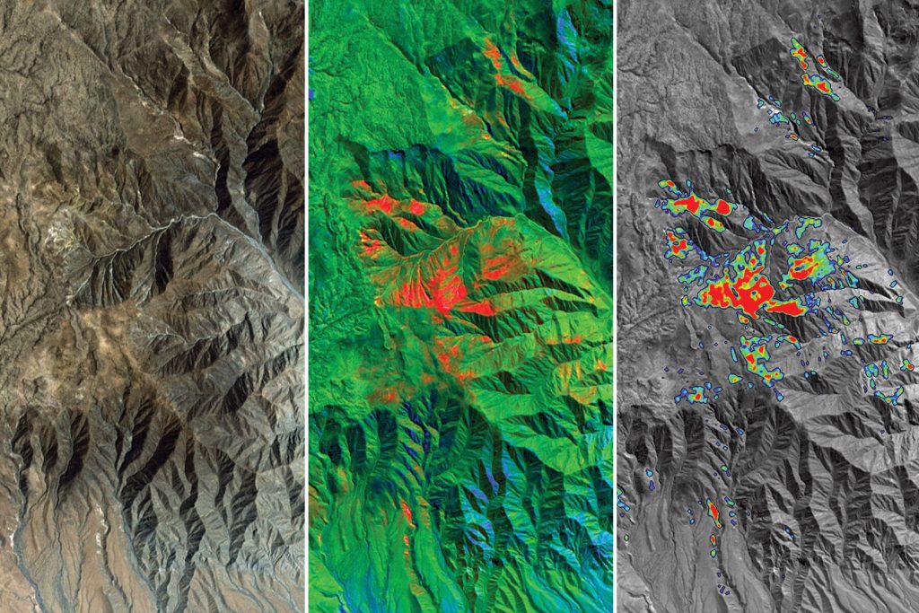
Our team of multi-skilled geological experts assimilates complex data sets to generate and refine targets, define controls on mineralisation, and delineate prospective structures and sequences. Integrating the data with our geological and structural knowledge enables us to identify geological processes, detect structures, and assess the likelihood of ore deposit accumulation. Critical to this, is evaluating the timing of mineralisation within an area’s tectonic history. This allows us to immediately define prospective targets that would not otherwise be defined, through direct detection methods.
We specialize in developing process-driven conceptual models to identify and improve the understanding of your mineral targets. By using multiple data sets, our highly experienced geologists solve geological ambiguities not resolvable with a single data set.
Services
- Interpretation of aeromagnetic and satellite imagery data to produce structural and geological maps that help target deposits.
- Ranking of exploration targets for specific deposit styles or commodities.
- Interpretation of 2D and 3D seismic data and integration with aeromagnetic interpretations to produce 3D models of basement architecture.
- Production of interactive GIS maps and models that clients can update over time.
- Customized, on-site, geophysical interpretation courses that train exploration geologists on the geological interpretation of geophysical data.
Shallow Geophysical survey
ERT (Electric Resistivity Tomography )
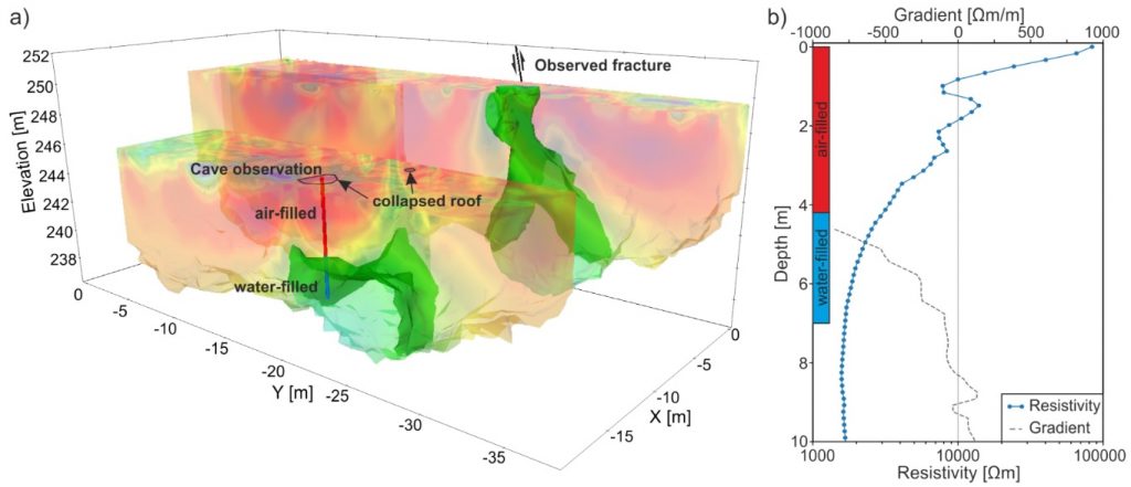
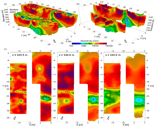
ERT is useful for subsurface mapping, as it can be used to generate pseudo-sections of the subsurface along a measured traverse. The results obtained can be viewed as modeled images of the underground. At the locations surveyed, the ERT technique proved successful in mapping the trace/ trajectory of the alluvial gravels at depth
GPR (Ground Penetration Radar )
Geologists and geophysicists rely on ground penetrating radar (GPR) to gather high resolution subsurface information rapidly.Compared to other geophysical methods nothing comes close in terms of the amount of ground coverage that is obtained with GPR. Several kilometres of terrain may be surveyed and with integrated GPS geological mapping and prospecting in remote regions is easily accomplished. Antennas ranging from low frequency antennas up to the higher frequency shielded antennas are all applicable depending on the degree of resolution and the depth of penetration desired.
Application includes:
- Depth to bedrock
- Sand and gravel mapping
- Placer mapping
- Groundwater exploration
- Stratigraphic mapping
- Mine Safety
- Hazardous fracture zone detection
We offer suitable solutions for geological or mining applications. The flexibility in the GPR Systems allows antennas to be pulled by hand or towed in various configurations behind ATV’s, vehicles, snowmobiles, or whatever other means is necessary to traverse the desired terrain.
GPR is frequently used to obtain the following geological information:
- Deep bedrock profiling.
- Groundwater resources.
- River & lake bottom profiling.
- Fractures characterisation.
- Sedimentological studies.
- Soil & aggregate mapping.
- Bathymetry studies.
- Polar research.
- Karst mapping.
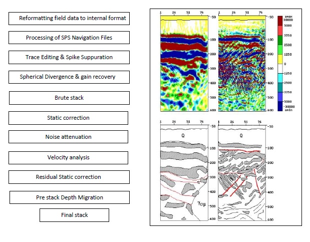
Shallow seismic processing and interpretation.
GSI has a recommended processing flow chart to process high frequency (about 2500 Hz) seismic data to interpret our target at the shallow zone (1-2 Km).
The shallow seismic exploration method has been used extensively in petroleum exploration and geological engineering, particularly in karst regions. However, whether or not it is suitable for solid-ore exploration is still speculative since solid ore deposits usually occur as irregularly shaped bodies (e.g., gold deposits outcrop as veins, keels and other shapes). It is necessary to increase the resolution of the seismic data in order to carry out solid-ore investigations into gold, silver, copper and other mineral resources.
The shallow seismic exploration procedure is principally divided into the following three stages: data acquisition, processing and interpretation. Using basic geological observations, we attempt to interpret geologically the seismic profiles obtained, which show various lithological interfaces. By means of comparison and discrimination of waves in the time domain, structural forms and contact relationships of the reflected layers, as well as the distribution of faults etc. , can be determined. However, the accuracy of these geological interpretations is always affected by certain factors, for example, the arrangement of the field observation system, the method of primary data collection, the method of data processing and the selection of parameters. Therefore, due to the complexity of the geological processes involved, in the course of exploration for solid mineral resources, especially gold and copper, there are several factors that must be very carefully considered. First, study of the metallogenic and geological conditions is important. Second, the selection of shallow seismic profiles, which relies on the fundamental geology, is critical. Finally, seismic results must be compared with real mining data to test the feasibility of the developed shallow seismic exploration technique